by WeatherOps, on Mar 26, 2014 4:15:22 PM
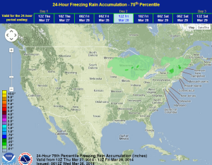
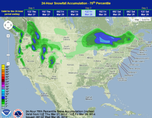
Moderate to heavy snow and light icing will be possible for portions of the Great Lakes tomorrow. Showers and thunderstorms will also be possible for portions of the Southern Plains and Mississippi River Valley; some severe thunderstorms will be possible. Rain and mountain snow will be possible for portions of the Pacific Northwest and into the Rockies. Some thunderstorms will be possible.
An area of low pressure moving east across the Great Lakes will bring snow and light ice to the region. 3-7 inches of snow with some locally higher amounts are possible. The front moving across the Plains and Mississippi River Valley will trigger some thunderstorms from the Gulf Coast through the Central Plains and Mississippi River Valley into the Southeast and Ohio Valley. The slight risk for severe weather extends from Northeast Texas to the Central Plains and Central Mississippi Valley. Large hail and damaging winds will be the main threats. A disturbance moving across the Northwest and Rockies may trigger some thunderstorms, as well as moderate to heavy snow for the Cascades and the Northern and Central Rockies.
Convective Outlook for Thursday
WDT preferred forecast for snow and ice accumulation through 8am EDT Friday