Moderate to heavy snow is possible on Wednesday for coastal areas of the Northeast and New England regions with blizzard conditions possible. Showers and thunderstorms will also be possible for portions of the Central Rockies and Southern Plains. Rain and heavy mountain snow will be possible for portions of the Pacific Northwest and Northern Rockies.
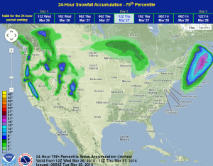
The low off the East Coast will continue to deepen as it moves northeastward. Rain, heavy snow, and strong winds will be possible across the Northeast and New England region. Sharp gradients in light and heavy snow will be likely. Hurricane force winds will be possible, especially along the coast. Showers and thunderstorms will also be possible for portions of the Southern Plains as an upper level disturbance tracks eastward from Mexico.
WDT preferred forecast for 24 hour snow accumulation through 7AM CDT Thursday