


by WeatherOps, on Mar 20, 2014 9:40:29 AM
Light rain and snow, as well as some lake effect snow , will linger across the Northeast. Light snow will also be possible for portions of the Intermountain West and Northern Rockies. Across the Northern Plains, showers and thunderstorms will be possible.
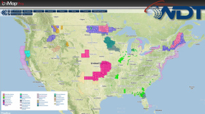
Current NWS Advisories/Watches/Warnings in iMapPro:
Rain and snow will linger across the Northeast this morning as an area of low pressure remains over the area. Some lake effect snow will also continue over the Great Lakes. This activity will gradually come to an end as the low continues to move northeastward. Where lake effect snow is occurring, 2-4 inches of snow will be possible. Across the Northern Plains, a fast moving clipper from the Intermountain West will generate showers and thunderstorms across portions of the Dakotas and Minnesota. Precipitation will transition to snow later this evening and into tonight with only light accumulations expected. Light snow is also possible for portions of the Northern Rockies and Intermountain West. Across the Southern Plains, strong winds, warm conditions. and very dry air will contribute to a very high fire danger.
