Light snow will be possible today for Northern New England. In the Desert Southwest and Southern Plains, showers and thunderstorms will be possible. Light to moderate snow will also be possible for portions of the Intermountain West.
Current NWS Advisories/Watches/Warnings in iMapPro
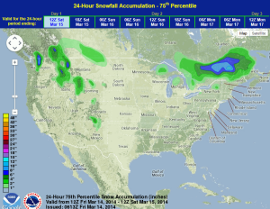
High pressure will move into the Southeast while another front will move into the Northern Great Snow is expected to develop north of the Great Lakes with little threat to the Upper Midwest and Great Lakes. Light to moderate snow is expected along the U.S./Canada border in the Northeast with most areas seeing less than 4 inches. Another frontal boundary will approach the Northwest and bring additional rain and snow to the region. Moderate to heavy snow will be possible for portions of the Cascades, Bitterroots, and Rockies. Accumulations should stay between 4 and 8 inches with locally higher amounts. In the Southern Plains, an area of low pressure will move out of the Desert Southwest and into West Texas. Severe weather is not expected, but isolated showers and thunderstorms are possible.
WDT preferred forecast for 24 hour snow accumulation through 7am CDT Saturday