by WeatherOps, on Mar 14, 2014 4:10:09 PM
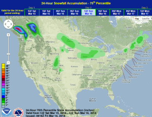
Light snow will continue for portions of the Northern Plains and Midwest on Saturday. Across the Southern Plains, showers and severe thunderstorms will be possible for portions of the Southern Plains. Light to moderate snow will be begin late in the day on Saturday across the Pacific Northwest.
A frontal boundary across the Northeast will bring light snow to portions of Northern New England. Accumulations will remain less than 4 inches. The area of low pressure currently affecting the Southern Plains will continue eastward into Oklahoma and East Texas. Showers and thunderstorms are expected through the region, with some severe thunderstorms possible. Hail and damaging winds will be the main threats, but isolated tornadoes cannot be ruled out. Snow will be possible for portions of the Northern and Central Rockies with accumulations remaining below 6 inches.
WDT preferred forecast for 24 hour snow accumulation through 7AM CDT Sunday