by WeatherOps, on Mar 13, 2014 4:44:48 PM
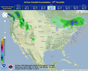
On Friday, light snow will be possible for northern portions of New England. Showers and thunderstorms will be possible for the Desert Southwest and Southern Plains. Light to moderate snow will be possible for portions of the Intermountain West.
High pressure will begin to build into the Southeasst while another weaker front will push into the Northern Great Lakes. Light to moderate snow is expected along the US/Canada border in the Northeast. Accumulations will be less than 4 inches in most areas. Another front approaching the Pacific Northwest will bring additional moisture to the area with moderate to heavy snow in the Cascades, Bitterroots, and Rockies. Accumulations of 4-8 inches will be possible with locally higher amounts. Showers and thunderstorms will also be possible for portions of the Southern Plains as an area of low pressure moves out of the Desert Southwest into West Texas.
Convective Outlook for Friday
WDT preferred forecast for snow and ice accumulation through 8AM EDT Saturday