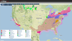
Moderate to heavy snow, as well as light icing, will continue for portions of the Great Lakes to the Northeast. Windy conditions will lead to reduced visibilities. For the Southeast and Mid Atlantic, thunderstorms will continue to develop. Some thunderstorms will have the potential to become severe.
Current NWS Advisories/Watches/Warnings in iMapPro
A frontal boundary will continue to advance through the Midwest and Eastern US, bringing moderate to heavy snow across the Great Lakes and the Northeast. In addition, moderate rain and thunderstorms will be possible through the Ohio and Tennessee River Valley. A slight risk for severe thunderstorms will also be possible this afternoon for portions of West Virginia, Kentucky, Virginia, and Maryland. Bow echoes with the potential for wind gusts over 50 miles per hour will be possible. A few isolated tornadoes cannot be ruled out.
Further north over the Great Lakes and Northeast, moderate to heavy snow is expected. Sustained winds will be between 10 and 25 miles per hour with gusts as high as 30-45 miles per hour. Snow accumulations will range from 6 to 20 inches with higher amounts possible. Visibilities will be reduced due to blowing and drifting snow. In addition, light freezing rain and sleet is expected from Ohio to Upstate New York. Significant ice accumulations are not expected and should remain under a quarter of an inch. Hazardous travel conditions are expected.
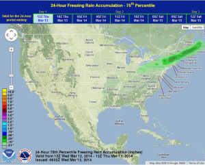
WDTY preferred forecast for snow and ice accumulation through 8AM EDT Thursday