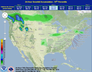
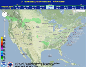
Light snow will continue for portions of the Central Plains and Midwest on Wednesday. Across the Southeast, moderate to heavy showers and light freezing rain will be possible across portions of the Southeast.
A shortwave trough will move through the Central and Southern Plains on Wednesday will allow for a light wintry mix across portions of Kansas, Oklahoma, and the Midwest. Temperatures will remain near or above freezing across much of Oklahoma, thus minimizing impacts. Snow will begin in western portions of Kansas and Oklahoma, moving eastward through the day. Areas of North Central Oklahoma may pick up some light snow before dark and the lift into Missouri and Illinois after dark. Light accumulations will be possible.
Elsewhere, showers and general thunderstorms across the Lower Mississippi River Valley region will shift into the Southeast. No significant impacts expected.
WDT preferred forecast for 24 hour snow and ice accumulation through 6AM Thursday