by WeatherOps, on Feb 28, 2014 3:59:40 PM
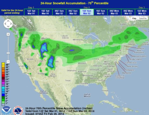
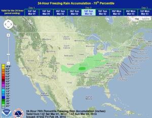
A strong area of low pressure across the Western US will allow for heavy rain and mountain snows across portions of California and the Rockies on Saturday. A surface front associated with an area of low pressure will move into the Northern Plains Saturday morning, allowing for light to moderate snow from the Northern Plains into the Northeast. On the southern fringes of the system, freezing rain and sleet is possible from portions of Oklahoma into Missouri and into Southern Indiana. Up to a tenth of an inch of ice will be possible. Isolated thunderstorms with thundersleet will be possible for portions of Missouri and points eastward Saturday evening.
WDT preferred forecast for 24 hour snow and ice accumulation through 6am CST Sunday