


by WeatherOps, on Feb 27, 2014 9:36:46 AM
Valley showers and isolated thunderstorms will continue today for portions of the lower elevations of California into the Rockies, with moderate to heavy snow in the higher elevations. Light lake effect snow will be possible for portions of upstate New York.
Current NWS Advisories/Watches/Warnings in iMapPro:
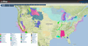
Arctic air continues to build across portions of the Central and Eastern US today. Widespread wind chill warnings are in place for portions of the Northern Plains, Great Lakes, and the Northeast. Wind chills as low as -30 are possible in some places across Northern Michigan. This cold air will continue to build across the country for the next few days. Additional wind chill advisories and warnings are anticipated. Across portions of California and the Rockies, an area of low pressure will bring showers and thunderstorms to the lower elevations and heavy snow to the higher elevations.
WDT Preferred Forecast for 24 hour snow accumulation through 6AM CST Friday
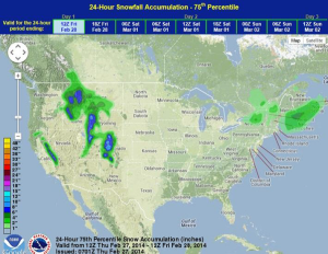
In addition to the snow across portions of Northeastern and East Central California, winds could gust as high as 80 miles per hour in the higher elevations. 12-24 inches of snow is possible for this area through Saturday.
