Showers and thunderstorms are possible today for portions of the Southern US. Across the Northern and Central Rockies, showers will be likely in the lower elevations and moderate snow in the higher elevations. Some light icing will be possible tonight for portions of Central Texas.
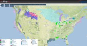
Current NWS Advisories/Watches/Warnings Summary in iMapPro:
A warm front across the Southern US will allow for scattered showers and thunderstorms extending from Texas to the East Coast. Later today, this front will begin to move eastward and then northward along the East Coast. As thunderstorms develop, rain, lightning, and winds to 40 mph will be possible. As colder air moves into Central Texas, some light icing and/or sleet will be possible. Low pressure will finally exit the Pacific Northwest and into the Rockies allowing for rain in the lower elevations and snow in the higher elevations.
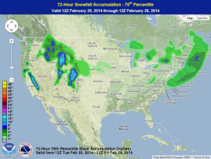
WDT preferred forecast for snow and ice accumulations through 6AM CDT Tuesday
It has been a cold winter across much of the country. In Chicago, for example, there have already been 22 days of lows below zero. The record, which was set in 1875, is 25 days and that record is in danger of being broken.