


by WeatherOps, on Feb 24, 2014 9:41:28 AM
Rain and snow will continue for portions of the Pacific Northwest today with rain in the lower elevations and moderate to heavy snow in the higher elevations. Light to moderate snow will continue for portions of the Northern Plains. Showers and thunderstorms will be possible for portions of Florida and a few isolated showers and thunderstorms will be possible for portions of the Southern Plains tonight.
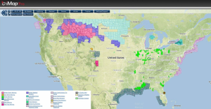
Current NWS Advisories/Watches/Warnings in iMapPro
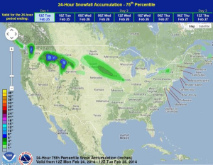
Moderate to heavy snow is continuing for the higher elevations of the Pacific Northwest and Northern Rockies with an additional 12-15 inches of snow possible. An area of low pressure will move into the Northern Plains, allowing for 3-6 inches of snow from portions of the Dakotas into Northern Illinois. Isolated showers and thunderstorms will also be possible across Eastern Florida and parts of the Southern US late in the day as a cold front begins to shift southeastward.
WDT preferred forecast for snow and ice accumulation through 6AM CST Tuesday
Travelers in Washington became stranded after a foot of snow fell across portions of Washington. Slick roads contributed to multiple traffic accidents. Roads were also closed in some areas due to the potential for avalanches. Another foot of snow is possible for portions of Washington through today.
