by WeatherOps, on Feb 24, 2014 4:00:43 PM
Showers and thunderstorms will continue for portions of the Southern US on Tuesday. In the Central Rockies, showers will be possible for the lower elevations and moderate snow for the higher elevations. Light freezing rain will be possible for portions of Central Texas Tuesday evening into Wednesday morning.
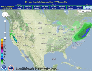
A cold front and area of low pressure will bring a chance of showers and thunderstorms to much of the Southern Plains and Southern US. While widespread severe thunderstorms are not expected, moderate to heavy rain, lightning, and wind gusts to 50 mph will be possible. An upper level trough will move out of the Pacific Northwest and into the Central Rockies, allowing for 4-8 inches of snow in the higher elevations. Light snow will also be possible for portions of the Mid Atlantic and the Northeast.
SPC Day 2 Outlook in iMapPro
WDT preferred forecast for snow and freezing rain accumulation through 6AM CST