by WeatherOps, on Feb 20, 2014 3:54:50 PM
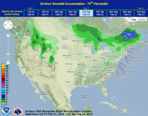
Severe thunderstorms are possible for portions of the Mid Atlantic and Southeast on Friday. Across the Upper Great Lakes, heavy snow and blizzard conditions will continue. Light to moderate snowfall will also continue across portions of the Rockies and Intermountain West.
The cold front moving eastward from the Plains will move into the Appalachians by Friday morning and the Southeast by Friday afternoon. Severe thunderstorms will also be possible, but a widespread outbreak is not expected. Damaging winds and large hail will be possible, however. Light to moderate snowfall will continue for portions of the Northern Rockies and Intermountain West.
SPC Day 2 Outlook
WDT preferred forecast for snowfall accumulation through 6AM Saturday