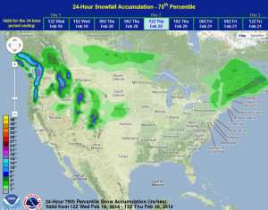
Another area of low pressure will bring rain and snow to portions of the Northeast on Wednesday. Strong lift in association with an upper level low will bring a chance of showers and thunderstorms to portions of the Plains and Mid-Mississippi River Valley Wednesday afternoon and evening. Lower elevation rain and higher elevation snow will continue for portions of the Pacific Northwest and Rockies.
WDT preferred forecast for 24 hour snow accumulation through 6pm CST Wednesday
As precipitation develops across the Northeast, it will initially be in the form of snow, but as temperatures warm, snow will transition to rain. Rain and snow will develop across the Rockies and the Pacific Northwest on Wednesday with heavy snow possible in the highest elevations.
An area of low pressure will develop in the lee of the Rockies, allowing for the development of showers and thunderstorms across portions of the Plains. Hail and damaging winds will be the main concern with these storms.
SPC Convective Outlook for Wednesday