Light to moderate snow is expected today from Arkansas into the Great Smokey Mountains with light to moderate icing possible from Northern Louisiana to Northern Alabama. In the west, snowfall will taper off for portions of the Central Rockies, but will increase for portions of the Northern Cascades and Northern Rockies.
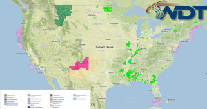
Current NWS Advisories/Watches/Warnings from iMapPro
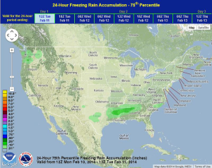
A few disturbances will continue to progress to the east along a frontal boundary moving off the East Coast, bringing precipitation to portions of the Lower Mississippi River Valley and the Southeast. Light to moderate snow is also expected from portions of Oklahoma and into portions of Mississippi, Alabama, and Tennessee. To the south of this snowfall, sleet and freezing rain is possible for portions of East Texas and Southern Arkansas and into the Carolinas.
Another area of low pressure will move into the Pacific Northwest on Monday and will lead to an increase in snowfall across portions of Washington, Idaho, and Montana. Over the next two days, over two feet of snow will be possible in portions of the Northern Cascades.
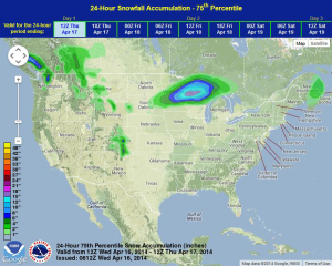
WDT preferred model for 24 hour snow and ice accumulation through 6AM CST Tuesday
Another winter storm is developing for portions of the Appalachians and the Southeast for Tuesday and Wednesday. 1-3 inches of snow will be possible for portions of the Southern Appalachians and into North Carolina. Across the Southeast, light to moderate of icing is possible from portions of Mississippi to South Carolina (a tenth to a quarter of an inch of ice is possible). Up to half an inch of ice will be possible for portions of Louisiana, Georgia, and South Carolina.