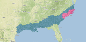
A winter storm is taking shape across portions of the Southeast as a bitterly cold air mass continues to move southward into the Southern Plains and Deep South. Here are the current Winter Storm Watches (Teal) and Winter Storm Warnings (Pink),
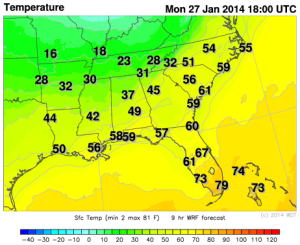
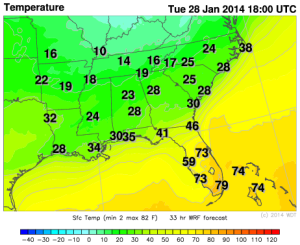
A cold front will move into the Deep South tomorrow and will drop temperatures below freezing for portions of Louisiana, Mississippi, and Alabama.
WDT WRF model Temperatures Monday 12pm CST and Tuesday 12pm CST
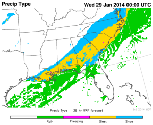
The cold front is associated with an upper level system over the Great Lakes and the Ohio River Valley. Ahead of the cold front, precipitation will begin as rain, before transitioning to freezing rain, sleet, and eventually snow. Along the Gulf Coast, 1-2 inches of snow, with locally higher amounts. Further to the east across southern portions of Alabama and Georgia, while temperatures at the surface will be below freezing, a deep layer above the ground will be above freezing. Due to this warm layer and temperatures below freezing at the surface, some freezing rain will be possible. In areas where the Winter Storm Warning is in effect, up to 3 inches of snow will be possible, in addition to some freezing rain and sleet.
WDT WRF model Precipitation Type 7pm EST Tuesday
In portions of Georgia and South Carolina, a quarter to half an inch of ice will be possible. This will have the potential to cause hazardous travel conditions and power outages, as well as damage to tree limbs.