


by WeatherOps, on Jan 24, 2014 9:41:07 AM
Freezing rain, sleet, and snow will continue for portions of the Gulf Coast through late morning or early afternoon today. Many of the Winter Weather Advisories and Winter Storm Warnings will expire around noon today as temperatures rise above freezing.
Current NWS advisories in iMapPro
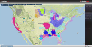
Across the Northern Plains, Blizzard Watches have been issued for portions of the Upper Mississippi River Valley. These watches are in association with a strong area of low pressure that will move into the Northern Plains later today. 1-2 inches of snow will be possible for portions of the Dakotas and Minnesota, in addition to wind gusts to 50 miles per hour. Lake effect snow will be possible across portions of the Great Lakes through today. 5-8 inches of snow will be possible for portions of the Lower Peninsula of Michigan, with some locally higher amounts possible.
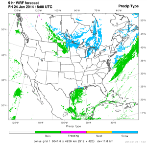
WDT WRF model Precipitation Type 12pm CST
Several automobile accidents have been reported in the Austin, Texas area due to the freezing rain. Williamson County reported 58 crashes between 7pm Thursday night and 6am this morning. Officials in Round Rock, Texas have reported 49 crashes between 5pm Thursday and 8am this morning. Freezing rain has also caused school delays and business closings as far south as Victoria, Texas.
